JPL is developing the core autonomy technologies required for aerobot (robot airship) exploration of solar- system bodies that have an atmosphere. While the primary target of exploration is Saturn's moon Titan, the core aerobot autonomy technologies are also immediately applicable for Venus or terrestrial aerobots.
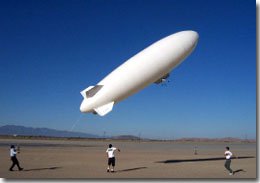
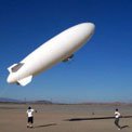
Fig. 1a: Takeoff of the JPL aerobot, conducted at the El Mirage dry lake in the Mojave desert.
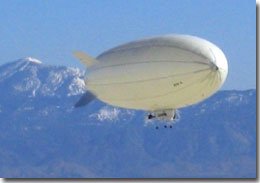
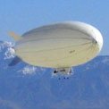
Fig. 1b: Autonomous flight of the JPL aerobot, conducted at the El Mirage dry lake in the Mojave desert.
The autonomy technologies currently under development address:
Research to address develop these technologies is conducted on a prototype aerobot test bed shown in Fig. 1. The airship specifications are as follows:
The avionics and communication systems are installed in the gondola.
The aerobot avionics system is built around a dual-stack computer architecture. One of the stacks is used for navigation and flight control, while the other is dedicated to image processing. Wireless serial modems provide data/control telemetry links between the aerobot and the ground station, and additional video transmitters on the aerobot provide downlinks of video imagery to the ground station. The human backup pilot can always reassert "pilot override" control over the aerobot.
Available navigation sensors consist of an IMU (angular rates, linear accelerations), a compass/inclinometer (yaw, roll and pitch angles), laser altimeter (surface- relative altitude), barometric altimeter (absolute altitude against reference point), and GPS (absolute 3D position). The vision sensors include two down-looking navigation cameras (one provides a 360o x 180o view, while the other has a narrower field of view).
The ground station is composed of a laptop, a graphical user interface for vehicle supervision, wireless data and video links, video monitors and VCRs, and a differential GPS (DGPS) base station that provides differential corrections to the GPS receiver onboard the aerobot, allowing vehicle 3D position estimates with an accuracy on the order of centimeters.
Extensive field tests of the JPL aerobot and the autonomous flight- control system have been conducted at the El Mirage dry lake site in the Mojave desert, and robust waypoint navigation has been demonstrated.